GIS Development Services About
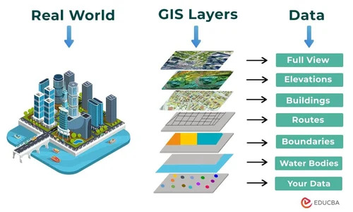
Experience the latest in GIS Development Services, designed for those who seek a rarefied standard of precision mapping. As a paragon supplier and trader based in India, our services allow you to reserve and grab fully customizable data layers-including full views, elevations, buildings, routes, boundaries, water bodies, and hot data. Serving spectacular applications like urban planning, infrastructure mapping, environmental analysis, and transportation networks, we output flexible formats such as Shapefile, GeoTIFF, KML, and GeoJSON. Enjoy seamless integration with ArcGIS, QGIS, MapInfo, with advanced visualization tools for web, desktop, and mobile platforms.
Key Features & Usage Areas
Our GIS Development Services offer a wide range of customization options for layers and data attributes, making them suitable for urban planners, infrastructure consultants, environmental analysts, and transportation network designers. The service type includes comprehensive mapping deliverables for analysis, decision-making, and development projects. Sophisticated outputs like layered map visualization and 3D modeling ensure adaptability across web, desktop, and mobile platforms, making these services ideal for diverse requirements and scalable applications.
Supply Ability & Certifications
We maintain robust supply abilities to meet client demand across India, providing certified deliverables in the agreed formats. Samples are available for evaluation, with a nominal charge deducted from the final proposal amount upon project handover. Each project proposal includes clear steps for customization and integration, ensuring a smooth transition from sample review to full delivery, providing assurance and reliability throughout our professional GIS services process.
FAQ's of GIS Development Services:
Q: How can GIS Development Services benefit urban planning and infrastructure projects?
A: Our GIS Development Services deliver multi-layered map data and 3D visualizations ideal for accurate urban planning, infrastructure mapping, and effective resource allocation. These insights help planners make informed, strategic decisions.
Q: What output formats are supported for GIS data delivery?
A: We provide data in popular formats like Shapefile, GeoTIFF, KML, and GeoJSON, ensuring broad compatibility and easy integration into major GIS platforms such as ArcGIS, QGIS, and MapInfo.
Q: Where can the developed GIS solutions be deployed?
A: GIS solutions can be deployed across web, desktop, and mobile platforms, offering users flexibility whether they're in the office or on site, and supporting a wide range of application scenarios.
Q: Can I customize data layers and attributes according to my requirements?
A: Yes, all layers and their data attributes can be fully customized as per client specifications, providing tailored solutions for diverse project needs and objectives.
Q: What is the process for requesting a sample and what charges apply?
A: Clients may request a sample, which is available for a nominal charge. If the project proceeds, this charge is adjusted against the final proposal amount upon handover, ensuring a transparent and client-friendly approach.

 Send Inquiry


 Send Inquiry

 Send Inquiry


